Revolutionizing prospecting and exploration in Yukon
Shawn Ryan is changing the face of prospecting in Yukon with incredibly innovative new technologies such as unmanned drones
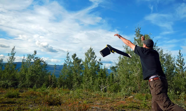
1 of 3Launching the eBee drone. — Photo courtesy Shawn Ryan
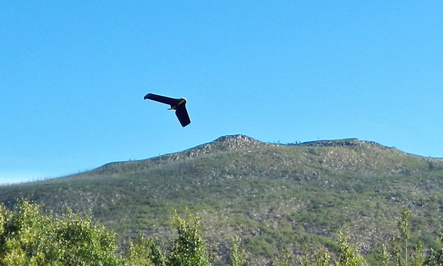
2 of 3The eBee drone in flight. — Photo courtesy Shawn Ryan
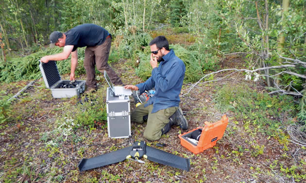
3 of 3Computer work in the field. — Photo courtesy Shawn Ryan
Shawn Ryan is changing the face of prospecting and exploration in Yukon in a way that's never been done before. The prospector who is credited with discovering Dawson's White Gold District and sparking a new Yukon gold rush is revolutionizing the industry with new methods for discovering gold. Ryan has been working with Isaac Fage and Tao Henderson, owners of GroundTruth Exploration based out of Dawson City, Yukon, to research and develop new ways to gather data.
What Ryan has been working on for the last year and a half is a new way to discover gold that will save his clients—the majority of which are junior mining companies—a lot of money. With his new method, gold is being found in a fraction of the time and at a fraction of the cost. As well, it is probably the most environmentally friendly way to explore.
What Ryan is doing for about $100,000 in about 2½ weeks' time is what used to be done with $500,000 over two field seasons.
"What we've done with GroundTruth Exploration is created a kind of ultimate exploration A team," said Ryan. "What we want to see is the best bang for our buck. We started researching about a year and half ago, realizing the downturn in this junior mining sector was coming. We could see it happening, so what we designed is basically a method that gives us the best bang for our buck and has actually turned into the most environmentally friendly prospecting method."
It all starts with better data
Ryan said it all starts with finding a soil anomaly. What they used to do when an anomaly was found was go in and trench the area where it was found with mini excavators. This is the same method that helped Ryan discover the White Gold District, but he thought there must be a better, more environmentally stable method.
"We brought in a system," he said. "Phase 1 starts with the broad soil anomaly. We go in and fly a small little eBee drone—(it's) about the size of a kite and weighs about 1.5 pounds. We fly the job site. What this gives us is a high-resolution photo down to about four to five centimetres. It gives a nice orthophoto and high-resolution DEM (topo) of the target area. It takes us an afternoon to fly it and allows us to process the information from that—which turns into the blueprint for the work site."
This drone allows Ryan and his team to basically gather and give an up-to-date orthophoto of the property in almost real time to their clients. A team member jumps out of the helicopter, sends the drone from the helicopter pad, has that data compiled in about two to three hours, goes back to process the information for the night and then by the next morning, they can start the next round of planning.
Borrowing and adapting technology
Phase 2 involves a direct-current (DC) resistivity survey (AGI SuperSting); this type of survey was taken from the environmental side of the geophysics world and has not been used in the hard-rock world yet, according to Ryan. He said they're still proving to the hard-rock world how great it's really working.
"We figured out how to increase resolution and limit line cutting with a new kind of high-resolution IP system," said Ryan. "The IP system includes 84 electrodes placed every five metres along a line. When all electrodes are in place, the system is turned on and data is collected. Then the electrodes get pulled out, the cable gets rolled up and the system is carried to the next line."
GroundTruth and the client then assess the orthophotos and high-res IP data in a 3-D program to see if any anomalies appear under the soil anomaly. If areas of interest appear, it’s time to test the rocks. This is where the Geoprobe comes in.
"The Geoprobe is on a lightweight hydrostatic rubber-track vehicle that has a low ground pressure and is designed to hammer holes down to the bedrock interface," said Ryan. "The idea is to hammer holes down on five-metre intervals, which allows us to evaluate the IP anomaly with very little surface disturbance. Hence, we save on the backfilling expense that occurred with the mini excavator method—plus, we are also doubling the daily trenching distance, so it’s a double savings in data gathering."
Results on the fly
The Geoprobe comes apart into two pieces that can each be slung by an A-Star helicopter. Once reassembled, the Geoprobe can trample through the bush. When it reaches a sampling location, its two arms fold out to create stability and the drill pops up to vertical and starts working. Within 10 minutes, the Geoprobe pulls bedrock samples from beneath several metres of soil.
The bedrock samples and the deepest 30 centimetres of soil are immediately tested with an X-ray fluorescence (XRF) gun, which provides rough assay information. If the XRF sees notable levels of gold or indicator elements, the company is notified and can adapt its exploration plans on the fly. And once it’s all done, the Geoprobe leaves behind almost no footprint.
The next component, which Ryan and his team started in October, is to use a rotary-air-blast (RAB) drill, which is on the same lightweight platform as the Geoprobe and should be able to go down to about 50 metres' depth. It gives the team a good indication of whether there is gold. The team is currently fine-tuning this method and performing case studies.
"To give you an idea of how we move . . . DC resistivity covers an area of about 420 metres and looks down about 90 metres," said Ryan. "With the Geoprobe, we get about 30 holes a day at five-metre intervals. Now we have pincushioned the best part of the 420-metre section and hopefully we light up one or two targets.
"We then go in with the RAB drill and do about four to five holes a day down to 20 metres. At this point we should have a good idea where the gold is or not. The idea is when junior mining companies go back looking for investments, they take our data that is now in a presentable 3-D format using the eBee drone, DC resistivity, Geoprobe and RAB drill results, and the investment fund guys can see the potential and are more willing to fund the next round of diamond drilling. They know where the gold is; they don't know what the true assays are, but investors know if they give them money, they're going to come up with something. It gives us confidence in the junior mining sector."
The benefits are huge
Ryan thinks that a year or two ago, this whole process using old or standard methods would cost a company about $500,000. He said he should be able to do the whole process for under $100,000. Ryan outlines what the old process looked like.
"Let's say a junior company finds a soil anomaly, they go in and trench it and let's say sometime in July they hit permafrost and have to come back in August," he explained. "They go in again, wait for the assay, then fall comes around and they're frozen out. They come back next year to tweak it and maybe get to drill in August. This is about a year-and-a-half-long process. We do it in 2½ weeks."
Besides the benefits of the speed and efficiency of the new system, the environmental footprint is miniscule. The base camp setup consists of one wall tent, a satellite dish and a few sleeping pup tents that all set up within an hour or so. They can engage their customers with live data feed from this field location while prospecting in the most environmentally friendly way possible.
Sharing the positives
As Ryan said, the cool thing about this method is that it's designed for shallow mineral exploration (top 100 metres), which is perfect for Yukon work. In Yukon, they're still just dealing with surface soil anomalies, or "picking up the low hanging fruit." But as Ryan said, this new method could also be used in places like Chile, Argentina, Sweden and Finland. Ryan and his team have gained government support and are currently performing case studies. They are going to present their findings in a Yukon Geological Survey Bulletin that will be presented at the Prospectors and Developers Association of Canada (PDAC) conference in Toronto in March.
"My goal is to show the world our results instead of hiding the data or keeping it a trade secret," said Ryan. "We all have to share ideas, especially when it comes to working in a much more environmentally friendly manner. We are all painted with the same brush and it doesn't matter if you are a prospector, a junior or major mining company. We need to help out our industry and exchange exploration ideas, since we are all in the same boat."