Geoscience BC releases first data reports on groundwater aquifers in the Peace Region
Geoscience BC today released the first two data reports on groundwater resources in the Peace Region of British Columbia, which will significantly improve understanding of the location of shallow saline and non-saline aquifers in the area. — Photo courtesy geosciencebc.com
Vancouver, B.C. – April 6, 2016 – Geoscience BC today released the first two data reports on groundwater resources in the Peace Region of British Columbia, which will significantly improve understanding of the location of shallow saline and non-saline aquifers in the area.
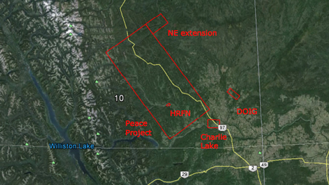
The SkyTEM Survey Report provides digital data from an airborne electromagnetic survey, which will be used to map the 3D configuration of shallow aquifers in the Peace Region. The survey was conducted over a 43-day period in July and August 2015 covering an 8,000 square kilometer area between Hudson’s Hope, Fort St. John and Pink Mountain. Researchers flew 20,099 line-kilometres along 400 metre-spaced lines, a distance equivalent to driving across Canada three times.
The helicopter used in the survey employed SkyTEM’s proprietary scanning technology with single purpose sensors that penetrate the top layers of sediment and bedrock, much like a CAT scan, to detect subtle changes in the ground that define the location of aquifers.
“The information released today is preliminary raw data from the Peace Project airborne electromagnetic survey,” said Carlos Salas, Vice President, Energy, Geoscience BC. “As we gain a better understanding of the geology of this region, Geoscience BC along with our partners will develop detailed maps of the area which will help First Nations, local communities, government and the resource sector make more transparent and informed decisions on sustainable groundwater management.”
The SkyTEM report provides details on the survey operations, data collection and results. It does not include any geological interpretations of the geophysical dataset. Report information is available on Geoscience BC’s data release page.
Geoscience BC also released a report on its assessment of the shallow geology over the project area (Interpretation of Quaternary Sediments and Depth to Bedrock Through Data Compilation and Correction of Gamma Logs), which will be used to better understand the geology and hydrogeology of the region.
Working with Petrel Robertson Consulting Ltd. and Quaternary Geosciences, gamma ray logs run through the surface casing of approximately 1,300 petroleum boreholes were recalibrated to map the characteristics of surrounding bedrock and sediment in order to identify the location of potential aquifers in the region.
Gamma ray logging measures naturally occurring gamma radiation to determine the physical property characteristics of geological formations and shallow unconsolidated sediments immediately surrounding the borehole wall, including the identification of rock type.
Information from this study is being used to support and confirm data collected from the airborne geophysical survey of the Peace Region to improve technical knowledge on the extent and accessibility of underground saline and non-saline water resources in the area.
The Quaternary Sediments report is available on Geoscience BC’s data release page.
Both these research initiatives are part of Geoscience BC’s Peace Project launched in March 2015 to map and characterize aquifers in the Peace Region of northeast BC. The Peace Project is a collaboration between Geoscience BC and ConocoPhillips Canada, Progress Energy Canada Ltd., the Northern Development Initiative Trust, the Canadian Association of Petroleum Producers through the BC Oil and Gas Research and Innovation Society, the BC Oil and Gas Commission, and the Province of British Columbia.
About Geoscience BC
Created in 2005, Geoscience BC is an independent, credible source of earth science information to attract investment and enable responsible resource decisions for the benefit of all British Columbians. Visit www.geosciencebc.com.